A Tour of Taroko National Park

A few weekends ago I explored Hualien City, the county seat of Hualien, with my friend Josh (who by the way is super talented and responsible for all of the pictures of myself that I included in this article.)

I wanted to show him one of Taiwan’s most scenic areas so naturally we ventured to Taroko National Park!

img_8156

This was a slightly ambitious one day trip, however from Taipei we were able to make it to the park and enjoy the sights all before it got dark. To maximize your time you just need to be sure to get up early the day of and do some research prior to arriving in Hualien City.

There are two methods of getting to Taroko National Park, the first being by combo ticket and the second by taking a direct train. The two are close in cost, with the direct train being the faster and more comfortable option. For more information on transportation between the two cities, consult this expertly written blog.

Josh and I decided before hand that we were going to rent scooters in order to travel at our own pace and have the freedom to chose exactly what areas of the National Park we wanted to explore. Once we arrived at the train station in Hualien City we were approached by the owner of a scooter rental shop and he quickly escorted us to his nearby shop. It cost $500 NTD (or $22 CAD) to rent them for the day and of course they came with helmets #safetyfirst

img_7760

If you don’t feel comfortable driving a scooter there are also buses that will take you there and you can learn more about how to catch it here under the <About the shuttle bus in Taroko> heading.

We were feeling adventurous that day so we found our way there using our good friend Google Maps, however my new favourite app Maps.me is also really good for directions and accuracy! Once you are out of the core city it is essentially a straight shot and the whole ride will take you approximately 40 minutes.

On the way to the park the views of the mountains were beautiful but once we reached an area just outside the park, the beauty we were immersed rose to a jaw dropping level.

img_8174

We proceeded to the Visitor Centre and got some helpful information from a very friendly park enthusiast. I recommend doing this just to take a break, go to the washroom, or buy a snack and some water.

We then took a left out of the Visitor Centre, went straight for 500 metres and eventually took a right following the signs for Taroko Gorge. We quickly noticed that everyone is required to wear helmets in the park due to the potential of rock slides, luckily we already had ours.

We road along the impressive Taroko Gorge until we arrived at the Swallow Grotto. The potholes found in the cliffs were especially impressive, not to mention the built in springs.

There is a trail you can walk that is about half a kilometre starting from the beginning of the Swallow Grotto, it’s called the Yanzikou Trail and it offers an up close and personal view of this impressive rock formation.

Since we rented scooters, we continued to ride along until we got to Cimu bridge where we stopped to take in the awe-inspiring architecture complimented by the surrounding astounding landscape.

img_8253img_8266

The rushing grey water that flows throughout these marble mountains is most likely this colour from the rocks and sediment below it, but there are places in the stream where marble rock is exposed and clear blue water is visible. This combination really is stunning in person and despite being completely natural, looks as if it was painted to be that way.

Next we found a waterfall that we got to observe from a nearby (somewhat nervewracking) suspension bridge. It was pretty wonderful to witness this raw and powerful display of nature.

img_8275


img_8289


Below is a map highlighting the major scenic spots within the Taroko Gorge. You can find out more details on the Taroko National Park website including various tour suggestions.

screen-shot-2016-11-15-at-5-19-28-pm


Personally, Taroko National Park served as a large reminder of how small we as humans really are. Everywhere you look at in this park, from any angle, you are surrounded by mountains and gorges up to 3,000 metres in elevation. The park is literal eye candy, a dazzling visual experience if you will. The greenery, the waterfalls, the shrines, and statues are all sensational and I guarantee you will say the word “WOW” at least five times during your time there. It is trips like these that emphasize how beautiful this world is and how important it is that we enjoy our world’s wonders in a respectful way.

Climbing the Dragon’s Back

One of my favourite adventures during my trip to Hong Kong had to be a hike called the Dragon’s Back. This duration of this hike depends on two factors: how fast you walk and how many pictures you take.

IF you’re the traveller who needs to capture every angle in their photos (me) I’d give it 3.5 hours, BUT it can be done in up to 2.5 if you move quickly.

What I find amazing about Hong Kong is that it’s city centre of impressively tall buildings is surrounded by mountains that not only offer a calm escape, but also incredible views.

The Dragon’s Back hike is well known. You can find reviews on TripAdvisor, that may suggest you book a tour or take a bus. And you can also learn more about the trail from LonelyPlanet, but if you’d like an inexpensive method, tried and true by yours truly, keep reading.

My friend Adalia and I woke up early one morning, grabbed the freshest take out sushi I have ever had, and headed to MTR station Chai Wan, located on the end of the Island line. Like many countries in South Asia, transportation cards for the subway, buses and street cars, can be purchased and reloaded at 7-11 locations; they take convenience store to a whole new level over here.

So if you’re visiting, grab an Octopus Card, it will definitely be worth your while!

Next I recommend taking Exit A from Chai Wan MTR station, where you will walk through a mall. Keep to the right and exit at the first outdoor walkway, also located on your right. Take the outdoor walk way and continue straight, perhaps 2 minutes, until you find a set of stairs to take you down.

how-to-dragons-back

Once you reach the bottom, walk across the street towards Wan Tsui Road, you should see the sign no problem.

Next walk straight on Wan Tsui for approximately 200 metres

Then take a left on Lin Shing Road. After turning left you have an incline walk, for roughly 350 metres. Once you reach the top of a small hill you’ll find an intersection and see the entrance for the Cape Collinson Catholic Cemetery across from you.

more-how-to-dragons-back

This sounds strange, and at first looks strange, but go through the entrance and walk up the first set of stairs towards your left.

Again it’s a tad odd, and you’ll think “Are these really the right stairs?” “Am I being punked?” But they are, and you’re not. Once you’re there you can’t miss them!

cemetery-stairs

Continue straight up these stairs, up to the very top, until you are out of the cemetery and into the nature! This part of the climb is steep so take your time, use the railing, and remember: the view IS worth it.

Keep walking up the steps until you come to a clearing. To your right you should see the wooden sign pictured here, walk towards the direction of Tam Tam Gap.

From here on out it’s essentially a straight shot! Just follow the road to the trail, which will eventually head left, and don’t stress, sign posts will indicate the way.

The first bit of the trail is shaded, and not much of an incline so it’s really nice. It is a bit rocky so make sure to watch your step.

img_8526

Next you will see a sign indicating the Dragons Back! It might be a little tricky to see at first so be on the look out for a point where the path diverges. Follow that sign and start walking up towards the left. And then keep walking. And then walk some more…

img_8618

Right about now is when you can start to get really excited because at this point you are CLOSE. If the sign’s aren’t enough, you should be able to gage it from the amount of sweat on your body, gotta love that Hong Kong humidity. 

Here I wasn’t even at the top of the peak and I was literally speechless!

Once we reached the summit, we not only felt super accomplished, but we were blown away by the scenery. On a good day, you can clearly see the nearby Shek-o Beach, as well as the area of Hong Kong called Stanley behind you.

img_7009

https://www.instagram.com/p/BJ58prbBPF1/?taken-by=careolinadoidge

Instead of going back the way you came from, I suggest you continue down the other side of the Dragon’s Back for some more amazing viewage. This direction is towards Shek-O Village, where you can have amazing Thai food and relax by the beach.

Once you’re back on flat ground, take a left out of the trail and wait for the #9 bus on the left side of the road to Shek-o Village! After Shek-O you can take the #9 back to the original MTR station you came from.

This hike has inspired me to attempt to climb Teapot Mountain 茶壺山 located near Jinguashi in northern Taiwan. This trail is much more difficult than Elephant Mountain, located in Taipei. Unlike the city views of Elephant Mountain, (20 minutes to climb), Teapot Mountain (4-5 hours to climb) lies in the heart of the wilderness on the northern coast, boasting views of the Pacific Ocean and even involving rock climbing at points.

Okay, so it’s ambitious, but after the Dragon’s Back I feel ready to tame another mountain!

Happy Hiking Friends! 

Dragon’s Back Route

More Hong Kong Hikes

Dusk at Elephant Mountain

As a girl from a small town surrounded by Lake Huron, I have seen my fair share of beautiful sunsets. However perhaps one of the most beautiful sunsets I have ever seen took place from my view at Elephant Mountain, just about a 15 minute walk from the famous Taipei 101.

DCIM107GOPRO
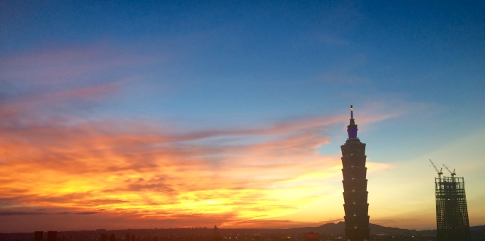
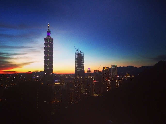
Elephant Mountain is the most famous of the Four Beast Mountain collection, which also includes Tiger, Leopard, and Lion Mountains.

There are actually two more mountains on this trail system called Nangang Shan and Jiuwu Peak that rise behind the beasts. Elephant  Mt. happens to be the part of the trail that links all these together.

Not only is this view of the city spectacular, it is also easily accessible by a 20 minute walk up the mountain (not to mention its free!!) The path to this glorious sight is made of stairs that are well maintained and include a railing so although steep, its not too difficult if you just go at your own pace.

IMG_6702

Although it will likely be busy the best time to go is during the late afternoon around 5-5:30 PM so that you can catch the sunset in Taipei, which currently occurs approximately 20 minutes after 6 PM (double check with your best pal Google). If you want to see the city landscape in daylight light, go earlier!

To get there by MRT, take the Red line 2 to its terminus, Xiangshan Station. You will be instructed to get off the Subway around the Da’an stop, but fear not, another car will be along shortly to take you to the end of the line, simply step off and wait for it.

Once you arrive at Xiangshan, take exit 2 out of the station and continue walking straight. You will notice a park and basketball courts to your left as you walk. Follow the signs for Xiangshan Hiking Trail and you won’t have any problems! When you reach the end of the road, walk across the street before you take a left, and follow both the fellow hikers and the corresponding signs. After a short distance turn right and soon you will have arrived at the base of the Xiangshan Hiking Trail.

Screen Shot 2016-08-29 at 1.07.41 PM

Take a swig of water, tie up those laces and prepare to be amazed.

You will come to a point on the trail where there is a picture taking pavilion. Although crowded there’s an unwritten code, people take their pictures and then move out of the way so that others may do the same. Be patient and you too will have your turn!

IMG_6710

To get the TRUE  birds eye view continue UP the path for not much longer and you will proceed to be amazed at how much of the city is visible.

In the backdrop you see mountains. In the foreground you see the impressive infrastructure of Taipei. Look right, left, and backwards; you will see greenery and perfect picture taking boulders to stand on.

Take pictures, take video, and then a deep breath and savour this moment because it really is so so breathtakingly beautiful.

IMG_6718

Once you take it all in I suggest walking back down to the pavilion area to get a great shot of the city lights after dusk. I guarantee you’ll be thinking about this scene the entire walk down, if not for the rest of the night. Did I mention you can see all this for free??

IMG_6760

To get a similar shot, have your camera ready between 6:30-7 PM, focus on the right side of your view and afterward use some good ole Instagram editing to really make the colours of that sky pop!

Wondering where this information came from? See for yourself! 

Elephant Mountain

https://guidetotaipei.com/visit/elephant-mountain-%E8%B1%A1%E5%B1%B1-xiangshan

Taipei Metro
 
The Four Beast Mountains
 
Xiangshan Taipei